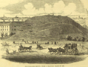
Regency (H)Not Spots: Whitechapel Mount

Whitechapel Mount from 1800Whitechapel Mount was an elevation of ground generally thought to have been composed in part at least of rubbish from the Great Fire Lysons however denies this Another idea is that it was a great burial place for victims of the Plague of 1665 A fort was built here in 1642 one of the series then thrown round London The Mount is shown in Strype's map of 1720 and in a view of London Hospital by Chatelain Towards the end of last century it was a place of resort for pugilists and dog fighters Mount Street and Mount Place immediately west of the London Hospital Whitechapel Road now occupy the ground which is still slightly raised London Signs and Inscriptions, 1897

The mysterious mount had a storied history that by the end of the Georgian era made it a popular place for human and dog fights.  The image was dated 1801 and shows how it would have been in the Regency era, before it was levelled around 1808 (Bard, 2014).  There are disputes about what year it was actually levelled, the excerpt below claiming 1805 and another source stating 1807.

Adjacent to the London Hospital on Whitechapel Road, was also known as Mount-row and one time served as a laystall (Cooke, 1833).  When it was levelled, numerous artifacts were found amongst the soil including an old pub sign, a silver tankard and a roman coin and attracted a raft of treasure seekers.  There are two primary rumours that circulated about the Mount without ever being proven.  The first was that it was the burial site for victims of the Great Plague.  The second, and most popular (and probably accepted as truth during the Regency era) was that it was where rubble from the Great Fire of London (1666) was placed.

It was levelled to make way for new roads (Mount Place, Mount Terrace and Mount Street) to access the East and West India Docks.  The soil was purportedly repurposed to make bricks, some which were used in buildings that still stand today like the Black Eagle Brewery.

as he was viewing the fortifications at this place in disguise 78 Whitechapel The fortress which was intended to defend the approach to the city from the Mount eastern road was situated within the parish of Whitechapel The dimensions of this earth work which was known by the name of Whitechapel Mount were 329 feet in length at the base and 182 in breadth The height above the level of the ground was about 25 feet The east end was till of late years very perfect on the west side fome houses had been built The surface on the top except where it had been dug away was perfe & tly level This Mount is described in Sir Chris topher Wren's plan of the new buildings at Mile end and is there called the Fort 79 It seems probable that a fortress was erected to defend each of the principal roads leading to the metropolis That at Mile end was called a Mount 180 in the diurnals of the seventeenth century We have traces of several mounts in the suburbs of London all of which were near the great roads Holywell Mount levelled some years ago was near the Hertfordshire road There are the remains of another in the way to Islington near thegreat north road The site of Whitechapel Mount which was levelled in 1805 has been since covered with buildings it belongs to the corporation of the city of London for the remainder of a term of 500 years for which it was leased by Lady Wentworth The Environs of London, 1811

Bard, R. (2014). Whitechapel & Stepney Through Time. United Kingdom: Amberley Publishing.

Cooke, G. A. (1833). Walks Through London: Or, A Picture of the British Metropolis : Containing Architectural Descriptions of the Buildings of the Cities of London and Westminster, the Borough of Southwark, and Their Environs …. United Kingdom: Sherwood, Gilbert and Piper.

Tagged , , , , , . Bookmark the permalink.

Comments are closed.